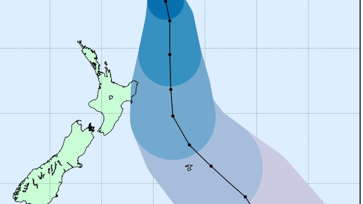
Cyclone Cody is expected to hit later today but the latest guidance is that it won’t make land and it will pass to the east of Aotearoa.
MetService forecaster Paul Ngamanu said the cyclone has moved slightly and would mainly impact the East Coast of the North Island.
He said they’ve put in place a heavy rain watch for Gisborne and the Eastern Bay of Plenty starting at 3am on Monday.
The only real impact on other parts of the country would be big seas, Ngamanu said.
On Friday MetService announced residents on exposed coastlines on the North Island should prepare for dangerously high waves of up to eight metres.
Flooding risks and power outages over the weekend had also been described as “highly possible” in eastern Bay of Plenty, East Cape, Gisborne and Hawke’s Bay by Weather Watch.
Gisborne Civil Defence emergency manager Ben Green said on Saturday they want to be prepared for any scenario.
“We’re probably as well set up as we can be going into what’s hopefully potentially just a glance of the system coming through.”
Green said they had been doing courtesy calls to make sure people in remote areas of the region are aware gale-force winds, intense rain and high seas were likely.
He said they were treating it as a worst-case scenario, particularly with people holidaying in remote coastal areas.
River levels are being monitored and there’s been additional cleaning of sewers and stormwater pipes, he said.
The transport agency, Waka Kotahi, said people should be prepared for large swells on low-lying coastal roads, as well as heavy rain and severe gales.
This kind of weather can cause slips, with debris and trees falling on the roads.
Waka Kotahi’s national journey manager, Helen Harris, said high-sided vehicles need to be particularly cautious in those types of conditions.
She said drivers of high-sided vehicles should consider not travelling until the severe weather dies down, even if the roads are open.
Crews will be monitoring the situation closely and will close roads if the weather gets too dangerous.
Surf Life Saving Northern Region (SLSNR) is also urging the beach-going public to take much greater care on northeastern beaches and prepare for closures as category 1 Tropical Cyclone Cody nears.
Northland’s patrolled surf beaches are at Ocean Beach, Whangārei Heads, Waipū Cove, Ruakākā, and Mangawhai Heads on the east coast and Ahipara and Baylys Beach on the west coast.
SLSNR lifesaving operations manager James Lea is warning beachgoers and holiday-makers to remain vigilant as large waves and strong rip currents create dangerous swimming conditions.
“With forecasted strong winds and a lot of energy pushing into eastern beaches this weekend, it will be extremely important to maintain your safety and safety of others this weekend. Strong surf and large waves will create strong currents,” Lea said.
“There will be a lot of water moving which would easily knock you off your feet. Keep a close eye on young children – be able to reach them quickly, see them at all times and stay well away from the water.
“We also ask that storm-spectators and rock-fishers take extra care if spending any time on the rocks this weekend. Large swells can easily knock you off and into the dangerous water.
Source: Read Full Article


