Weather: Met Office issues yellow warning for snow and ice
We use your sign-up to provide content in ways you’ve consented to and to improve our understanding of you. This may include adverts from us and 3rd parties based on our understanding. You can unsubscribe at any time. More info
Britons have been warned to brace for “disruptive snow” and possible blizzard conditions before gales and storms smash into the UK next week. The bitterly cold snap is continuing to grip the country, with the Met Office issuing an amber “danger to life” warning for ice covering large parts of England for Sunday. Nearly all of the UK is covered with yellow weather warnings on Sunday, ranging from snow and ice to fog and rain.
But forecasters have warned the nation to brace for more heavy snow over the latter part of this weekend before another unwelcome change that will bring heavy rain, strong winds and even the possibility of a storm.
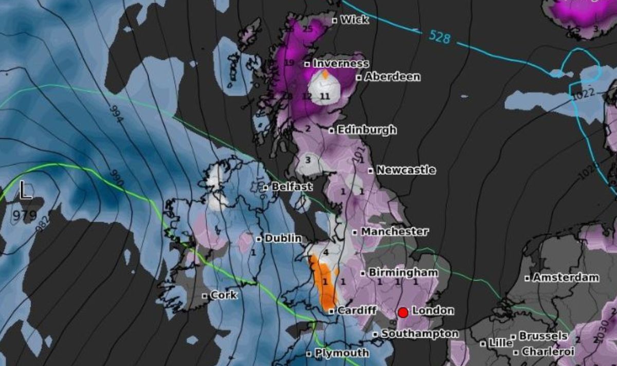
The latest weather maps from WXCHARTS show large parts of Britain once again under threat from snow this evening, with up to 25cm falling on higher ground in Scotland and a possible dusting throughout much of England.
This trend will continue into Sunday morning and heading into the afternoon, a part of the Scottish map turns icy white as the snowfall intensifies, with 12cm forecast to fall in an hour in central regions.
The snow could linger on Monday but a huge band of rain sweeping in from the Atlantic could put an end to that, with up to 15cm drowning parts of southern England and Wales.


Britons will continue to freeze tonight as large parts of the UK turn icy blue, with lows of -6C in northern Scotland and as low as -4C between London and the Midlands.
The bitterly cold temperatures continue on Sunday morning that could see the mercury plunge to as low as -8C in Scotland and -3C in southern England.
But the UK weather maps also show strong winds from the Atlantic smashing into southern parts of England on Sunday afternoon, with more heavy winds battering nearly all of the UK on Monday.
Brian Gaze from The Weather Outlook told Express.co.uk: “Disruptive snow is most likely in northern England and Scotland during Saturday night and into Sunday before the mild air arrives and snow turns back to rain.

“Gales could become an additional hazard this weekend and early next week, particularly in the southern half of the UK.
“Beyond that the details are still up for grabs, but at the moment it looks as though cold Arctic air will be pushing back into the north of the UK and it brings a renewed risk of snow.”
In his latest online weather forecast, Mr Gaze wrote: “Tomorrow, wet and windy weather pushes northeastwards across the UK. Outbreaks of rain are likely to be preceded by a period of snow in central and northern Britain.
“In the north significant accumulations and blizzard conditions are possible. Turning much milder in the south and west.
DON’T MISS
After the Netflix whine-a-thon, can Harry and Meghan sink any lower? [OPINION]
Prince Andrew sells luxury Verbier ski chalet for £19million [LATEST]
Voters back Sunak’s plan for new law to deport illegal migrants [POLL]


“Monday brings showers or longer spells of rain to much of the UK, although it could be drier in the east. Windy and very mild, particularly in the south.
“During Tuesday a band of rain clears southeastwards to leave brighter skies. However, showers push into western counties and Scotland where they could turn wintry. Mild in the south. Windy generally, and there is a risk of gales in the north west and western coastal counties.”
AccuWeather Senior Meteorologist Tony Zartman said earlier this week: “A storm will be approaching from the southwest this weekend. As it approaches from the southwest it will bring a surge of moisture into the UK, but it will also bring a surge of milder air.
“Initially, as the moisture runs into the cold air that remains in place, there can be some snow on Sunday. Where that occurs will depend on the location and timing of the advancing moisture and the advancing milder air, but, the greatest chance for snow initially from the storm will be across the northern UK.”

AccuWeather Meteorologist Alyssa Smithmyer also told this website: “An unsettled pattern will bring rounds of rain and showery spells to the UK this week.
“Occasional snow showers can develop across the Scottish Highlands, but moderate temperatures across the remainder of the UK will allow any precipitation to fall as liquid rain or showers rather than frozen.
“Lighter snow showers are likely off and on in the Highlands and other areas of higher ground through late week with some snow accumulation (generally on the order of 1-3 inches with each event), but by later this week the potential arises for the higher ground in Scotland to get higher amounts on the order of 3-6 inches.
“So generally, it will remain stormy with some windy days across the UK, but temperatures will turn warmer for the latter half of December (particularly across the central and southern UK) and be too warm for snow events comparable to the previous week.”
Source: Read Full Article


