BBC Weather forecasts above average temperatures across UK
We use your sign-up to provide content in ways you’ve consented to and to improve our understanding of you. This may include adverts from us and 3rd parties based on our understanding. You can unsubscribe at any time. More info
An area of high pressure is on course to build across northern Europe and over the Atlantic before moving towards the UK. Sunny spells and plumes of warm air is expected to be felt across south western areas of the UK from the start of next week.
Alyssa Smithmyer, meteorologist at AccuWeather, predicts a jet stream may then send the barmy conditions further north.
The flowing northerly winds are poised to draw hot air from Spain and Portugal, with “above average” temperatures forecast.
Ms Smithmyer told Express.co.uk: “As the week begins, it is likely that high pressure will linger to the southwest of the UK, to the west of the Bay of Biscay, along with a separate area of high pressure across north eastern Europe.


“It is possible that the high pressure west of the UK over the Atlantic remains to the southwest of the UK for the majority of the week, with slight westward and northward migrations to the centre of pressure over the Atlantic as the week continues.
“A scenario may occur in which the high pressure to the southwest shifts north eastward towards the UK by the end of next weekend, however, this depends on factors such as the position of the jet stream and how deep the trough may develop by next weekend.
“If high pressure does shift over the UK, it increases the likelihood for temperatures to range a few degrees above normal by the weekend as warmer air from Spain and Portugal can be swept northward towards the UK.”
Temperatures are expected to push towards 20C, with highs of 19C forecast in the South.


Ms Smithmyer says the mercury will be up to 3C above average for the time of year.
She added: “Next week, daily maximum temperatures are forecast to range 15 and 19C across southern regions, and range 10-15C across northern regions with cooler spots in higher elevations.
“Generally, at the start of the week many locations will see temperatures that are hovering 1-3C above normal for this time of September.”
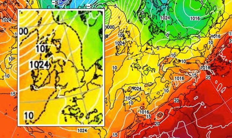
The latest temperature maps produced by Netweather show vast areas of the UK turning a dark shade of orange on Tuesday, September 21, as heat from the continent moves in a north westerly direction.

The model shows a significant area of high pressure building in Europe next Tuesday and into Wednesday, September 22.
Parts of France and Spain can be seen turning a shade a dark red as temperatures are predicted to reach the mid-twenties across the Channel.
The period of warm weather is expected to be disrupted towards the end of next week as area of low pressure threatens.
Temperatures are set to take a hit and drop towards the low-teens as a band of rain heads towards Britain.
DON’T MISS
Nigel Farage taunts France over AUKUS deal as he hails ‘Anglosphere’ [INSIGHT]
Royal Family LIVE: Meghan Markle fans furious with UK [LIVE]
UK weather forecast: Temperatures set to soar – latest maps [FORECAST]


Ms Smithmyer added: “Nearing the middle and end of next week, a more unsettled pattern is forecast to develop across the UK, which can help to lower daily maximum temperatures and allow them to hover near or slightly-below average.
“A frontal boundary is forecast to pass over the region by midweek and an area of low pressure can likely follow behind it.
“Both of which can bring cooler days along with widespread showers and rainy spells to the region.”
Source: Read Full Article


