BBC Weather: Chilly temperatures forecast across UK
We use your sign-up to provide content in ways you’ve consented to and to improve our understanding of you. This may include adverts from us and 3rd parties based on our understanding. You can unsubscribe at any time. More info
Winter weather is well and truly on the way, with an area of low-pressure forecast to bring icy northerly winds to the UK, seeing temperatures drop significantly. While the weekend has been sunny and mild, conditions will change in the coming week according to the latest weather maps and forecasters.
Monday will be another sunny but cool day which Netweather forecasters owe to an area of high pressure driving the weather for the first part of the week.
However, by mid-week conditions will change and you may notice a distinctly chilly feel in the air.
The area of high pressure will head west, which forecasters explain will allow an area of low pressure to reach the North Sea, travelling southeast from Iceland.
The low pressure will bring cold, northerly winds across the UK from Thursday – triggering showers which could potentially turn wintry.
Read More: BBC Weather: Brits warned as temperatures to drop below freezing

These showers are likely across “northern Scotland and down along eastern and western coasts.”
You may also wake up to frost, with widespread frosty nights likely.
Netweather forecasters say from Thursday, temperatures will hit 4C to 7C at best.
The mercury could reach as low as -2C in Scotland this week.


Will it snow this week?
The showers on Thursday mentioned above have the potential to turn wintry, especially over the north of England and Scotland.
Met Office forecaster Alex Deakin said: “There may be some snow in places next week.
“Enhanced rainfall over the Indian ocean has the potential to impact on the jet stream which is meandering above the Himalayas.
DON’T MISS
Cold weather payment: Is your area eligible? How to check [EXPLAINED]
UK snow forecast: Fog, frost and bitter winds as -8C chill hits [FORECAST]
Prepare to ‘scrape ice off the car’ as -1C plume to bring freeze [INSIGHT]
“This could force the jet stream further south bringing cold air southwards and a meeting relatively warm system across the western Pacific.”
If you live on higher ground you could see some snow this week, with Netweather forecasters adding the west of Scotland could see snow on lower levels.
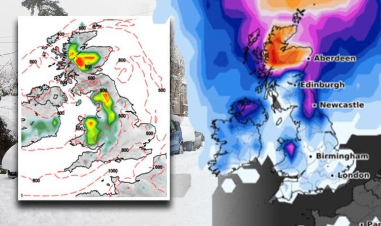
Looking at Netweather snow-risk maps for Thursday, much of Scotland looks to potentially see some flurries.
One map, dated Thursday, November 25 at 9am shows snow to the north of Scotland, spreading into the centre of the country.


By Friday, there will be another bout of showers, this time heavier, with again the chance of them being wintry.
For the northern Highlands, there is the chance of “a fair bit of snow” to fall.
Snow-risk maps for Friday again show flurries over Scotland, with some also over the north of England and Wales.
On Friday at 6pm, snow is at risk of falling in Scotland, the North West of England and much of Wales.
Heading into next weekend the cold, northerly winds will remain driving more showers towards the coasts and potentially inland.
The north will again see some snow on higher ground, with the potential for it to head lower.
What do other snow maps show?
Maps from WXCharts give a strong probability of snow falling on Wednesday, Thursday and Friday this week.
The charts show snowfall is likely on Saturday and Sunday too.
On Wednesday the probability of snow falling in Scotland is as high as 85 percent, with this dropping to 20 percent for the north of England, Northern Ireland and Wales.
On Thursday this risk increases, with a 90 percent chance of snow in the north of Scotland, up to 50 percent down to Newcastle and 15 percent widely elsewhere in the UK.
Source: Read Full Article


