California’s April snowpack is among the largest in state history, tied with 1952 for the title, according to new data out Monday.
Why it matters: The staggering amount of snow, delivered by 17 atmospheric rivers since December, brings flooding concerns with the melt season set to begin.
- The historic snowfall caps a dizzying lurch from extreme drought to flooding, consistent with predictions from climate change studies.
By the numbers: The start of April snow survey, which coincides with the typical seasonal peak of the state's snowpack, showed that there was 126.5 inches of snow on the ground Monday at the Phillips Station south of Lake Tahoe.
- It had a snow water equivalent (SWE) of 54 inches. This was 221% of average for the date at this location (SWE indicates the amount of water contained in the snow cover and is used for forecasting water supply and runoff).
- The Department of Water Resources’ (DWR) electronic snow sensors indicate the statewide snowpack has an average SWE of 61.1 inches, or 237% of average for the date.
- This exceeds any other year since the beginning of the electronic network in the mid-1980s, according to David Rizzardo, DWR's hydrology section manager.
- The 1952 April 1 statewide summary, made manually, was also 237% of average, Rizzardo said during a press briefing Monday. He noted that this year’s manual data, which is on par with 1952, is preliminary; more readings will filter in.
Between the lines: California typically sees large year-to-year precipitation variability, but even by this reputation, the past decade has been wild.
- Michael Anderson, California’s state climatologist, told reporters that only one out of the past 10 winters has fallen into the expected range.
- Studies show that climate change is making California’s weather whiplash episodes more extreme, with sharper and more frequent shifts. It is also intensifying droughts in the Southwest, including the still ongoing regional megadrought.
- The extraordinary variability presents challenges for water managers, who last year at this time were incorporating the Phillips Station's paltry April 1 snow survey reading of just 2.5 inches into their forecasts.
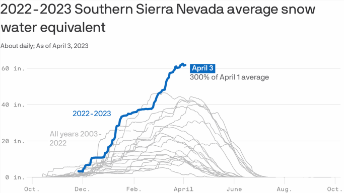
What’s next: The snowpack varies across the state, with the highest amounts compared to average in the Central and Southern Sierra. At 306% of average for April 3, the southern Sierra is at an all-time average SWE record, Rizzardo said.
- This has consequences for downstream flooding, since runoff from these mountains will flow into the San Joaquin Valley. Flooding is already occurring in southern parts of this region, even before the snowmelt has begun.
- Communities throughout this agricultural region fear a long duration flood is coming.
The bottom line: “I believe there is valid reason to be very concerned,” Rizzardo said of the San Joaquin Valley flooding potential.
Source: Read Full Article


