UK weather: Met Office predicts mix of cloud and sunshine
We use your sign-up to provide content in ways you’ve consented to and to improve our understanding of you. This may include adverts from us and 3rd parties based on our understanding. You can unsubscribe at any time. More info
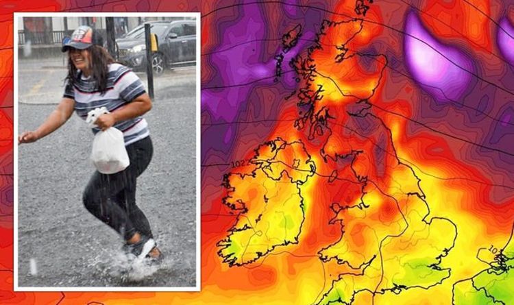
According to a weather chart by WxCharts layers of dark red and dark purple, indicating strong wind gusts, are seen swirling across the Atlantic eastwards towards Britain. The chart, which is valid for September 4, shows the above-average wind gust could hit the country at the beginning of the next month. The same chart also shows strong winds hitting the north of the nation on September 8. At one point during the day, the wind speed could hit as high as 46mph in the north of England and Scotland, the chart suggests.
And BBC Weather’s long-range forecast warned about low pressure systems moving in.
Its forecast from Monday August 30 to Sunday September 5, read: “High pressure looks a bit more likely to stick around through the bank holiday weekend and into the first week of September before gradually declining away.
“This means the first few days of autumn will tend to keep things largely dry across the UK with some warmth in western and northern areas.
“With high pressure to our northwest, a cooler easterly wind in the North Sea and southern half of the UK will keep the temperatures a little below average there.


“Towards the first weekend of September, there are some signals that low pressure may begin to push in as the high starts to weaken and shift north.”
It comes as forecasters have warned about storms sweeping across the country later in September.
Brian Gaze, a forecaster at The Weather Outlook, claimed the UK tends to get more low-pressure systems beginning to push from the west, and some of those can be the remnants of hurricanes that make their way towards Britain across the Atlantic.
Mr Gaze added that sooner rather than later the dry spell the UK is currently experiencing will end, bringing a “greater risk” of rain.

He told Express.co.uk: ”At the moment the computer model data which I’m looking at, which goes out about a month ahead, is suggesting this transition into more unsettled weather during the second half of next month.
“What looks like happening at the moment, perhaps by the end of first week of September, it may well be turning more unsettled in the northwest of the UK and then that more unsettled weather with rain will probably spread south-eastwards through the second week of September.”
Jim Dale, forecaster at British Weather Services, added with the UK experiencing “tranquil” and “stable” weather for a few weeks it means that there is a slightly bigger chance of storms heading to the UK.
Mr Dale said: “These last couple of weeks, we seemed to have been locked in high pressure, which is producing stable weather.
DON’T MISS
Boris Johnson warned UK ‘much more vulnerable’ to terror [VIDEO]
GB News’ Kirsty Gallacher ‘disgusted’ as vandals kill 1 mllion bees [REVEAL]
Sturgeon’s obsession mocked in BBC skit: ‘Blood thicker than Juncker’ [REPORT]


“Stable weather isn’t unusual not at this time of year but it tends not to last, and once you’ve had a good run with it, you tend to get into the other side of the coin. And that’s the weather from the Atlantic coming in.”
Mr Dale added that in the worst-case scenario, the UK could see an ex-tropical depression that could bring a “deluge of rain”.
The forecaster said: “You can get a few inches of rain in a short duration, along with that of course the stormy wind and storms.
“How deep they go and what impact they have will depend on what’s contained within them and by that I mean particularly the rain side of things if it drags in some tropical air.
“All of this begs a question if we will see something more tropical.”
Mr Dale continued: “It’s calm before the storm. It’s that scenario, the silence before the storm and that could well materialise.
“I’m not saying it will. But we should have good notice before them arriving and we should have a good warning before the storms come.
“So we should be able to warn people before anything that could have severe or catastrophic impacts arrives in the UK. But that’s the way it looks.“
“So we should be able to warn people before anything that could have severe or catastrophic impacts arrives in the UK. But that’s the way it looks.“
Source: Read Full Article


