A wet, windy and possibly snowy start to the morning is expected as “a pretty nasty cold front” moves up the South Island and across the North Island.
Severe weather impacts are expected in Southern New Zealand where there will be “very strong and rather chilly southwest winds”.
MetService meteorologist Angus Hines said there is a chance of snow in some of the elevated parts of the lower South Island, with several snow warnings in place for Fiordland and a snow watch is in place for the high parts of Clutha, Southland and Central Otago.
This is the first issued snowfall warning of the year but Hines said the expected snow is “reasonably low for May”.
❄️LATEST DEVELOPMENTS ❄️SNOW SHOWERS POSSIBLE OVERNIGHT TO 700M ❄️Good evening everyone.This morning we published…
Those planning to travel across the higher parts of the South Island should check the NZTA journey planner for any road closure updates, with a number of road snow warnings in place in Southland and the Central South Island.
North Island commuters might want to pack a rain jacket and umbrella, Hines said Tuesday morning is expected to be wet.
A band of rain is expected for most of the North Island this morning, with strong and gusty winds also expected.
Rain which is expected to cross the North Island today has a chance to turn heavy, with the chance it may turn into thunderstorms.
The wild weather is expected to calm later in the day but there may be brief showers.
/cloudfront-ap-southeast-2.images.arcpublishing.com/nzme/5TGL2LRYQP7XM2MLIUFQ7B3BMI.jpg)
“Most places are going to get a fairly breezy day,”Hines said.
Commuters also might want to wear an extra layer or two, with strong wind warnings in place for several parts of the country.
“We are expecting the strongest wind to be in the eastern North Island, [with a] warning in place for the Tararua district and southern Hawkes Bay,” Hines said.
A number of strong wind watches are also in place for the far southeast of the country, where a strong southwesterly wind is expected.
Although the temperatures haven’t dropped that much, Hines said “it’s gonna feel a bit cooler”.
Cold weather is expected for the lower South Island while it is expected to be warmer in the upper North Island.
“The maximum temperatures don’t look particularly frigid,” Hines said.
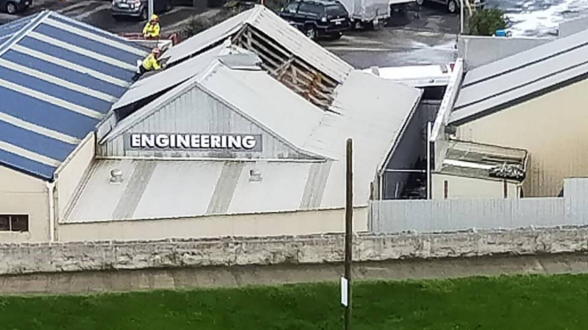
Yesterday, a tornado swept through the Taranaki town of Waitara, damaging buildings and sending trampolines “flying about”.
/cloudfront-ap-southeast-2.images.arcpublishing.com/nzme/I3GQYCBBG4K3ZKVWE5FMKOD2PE.jpg)
Taranaki Civil Defence Emergency Management said it had received reports of the twister and that fire crews had been dealing with the situation.
McFarlane Motors in Waitara was in the tornado’s path and Brook Prentice said they’d lost parts of their roof flashing as the tornado swept through, and pieces of their neighbour’s roof had ended up on top of their workshop.
Source: Read Full Article


