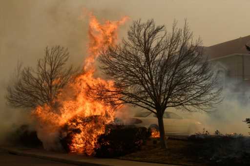
April has been a month full of fire danger in Colorado.
With the exception of just two days — April 1 and 2 — every day this month has been accompanied by some kind of formal warning about fire danger.
So far, the number of red flag warnings that have been issued this April is higher than any April in at least the last 15 years.
As we near the end of the week, Colorado’s fire danger will again rise to critical and extreme levels. We’re looking at what could be the worst fire danger conditions of the year Friday along the Front Range and across the Eastern Plains.
Fire “season” doesn’t normally ramp up until June and July, but as we’ve seen in the past few weeks and months, we can have fires outside of the “normal” times that wildfires are expected.
Many factors go into forecasting high fire danger. Winds, humidity levels, soil moisture, vegetation and temperatures all play a role in creating high fire danger. An incoming storm may bring relief to our dry soils this weekend, but that same storm will be the cause of our high winds before any moisture arrives.
It’s been windy this month. Denver has averaged 10 mph to 15 mph sustained winds every day so far in April. Areas near the foothills and Eastern Plains have seen even higher sustained winds this month.
Much like a hairdryer uses wind to dry hair, the wind outside aids in drying out the soils and vegetation. Denver has not picked up any rain or snow since March 17, and although we had a rather wet February and March, the benefit of that additional moisture has been almost completely eliminated by this point.
The incoming storm will move from the Great Basin of Nevada, across Colorado and into the Dakotas. That puts Colorado in the dry slot with southerly winds initially. As this storm strengthens, it will bring very gusty winds with it, and thanks to the direction that the winds will be blowing, air will be drying out even further as it flows down from the high terrain of the Rocky Mountains.
Winds are expected to reach advisory and warning criteria Friday across eastern Colorado. That means wind gusts are expected to reach over 50 mph at times. Some areas on the Eastern Plains should prepare for 50 mph to 60 mph winds while areas closer to the Interstate 25 corridor should expect 30 mph to 40 mph winds.
With winds this strong, blowing dust is expected, which can significantly reduce visibility when driving. Humidity values through the day on Friday are expected to reach critically low levels. On Friday, humidity values may drop as low as 5% to 7% across much of eastern Colorado.
The combination of intense winds and critically low humidity — and temperatures in the 80s — is plenty to trigger fire danger.
On top of this, Denver and the surrounding areas have seen a minuscule amount of moisture this month and, with how windy it has been, the amount of moisture held within the top layers of the ground has decreased substantially. If a fire were to ignite, not only would it move extremely quickly because of the winds, but it would have endless fuels to burn thanks to the lack of moisture around.
We will continue to have to be diligent about not sparking fires this week and, on Friday especially, precautions should be taken to minimize any chance of sparks. No open flames, no grilling, check to make sure chains from trailers aren’t dragging on the road, do not throw cigarette butts out the window, no fireworks, no anything.
As mentioned, the storm moving through will bring some relief to our dryness, but that won’t happen until Saturday and Sunday. Mountain locations are expecting to get decent snow this weekend. The Urban Corridor from Colorado Springs to Fort Collins is expecting light rain showers this weekend.
Yet total precipitation may not eclipse a quarter of an inch in any particular location, which will lead to lesser fire danger but not long-term relief. Another factor worth watching is the chance for severe weather across the eastern Colorado border.
Friday is going to be a very active weather day with snow, erratic fire behavior, blowing dust and severe storms all a possibility. With that said, the fire danger may be the most impactful.
Please stay alert through Friday to fire danger. Whether you live in a fire-prone area or not, you should prepare what you need in case you have to evacuate quickly. We’ve been experiencing quite the pendulum of extremes within the last year and it’s seeming like we’re once again swinging back toward the extreme dry side of things.
Source: Read Full Article


